Gravimetry
A gravimetric survey determines the gravity force of the underground with a highly sensitive gravity meter. The observed gravity differences between different points provide information about the distribution of masses in the underground and subsequently about differences of the rock physical parameter density ρ. This way natural or anthropogenic cavities, subrosion zones or other inhomogeneities of different densities can be detected in the underground by a nondestructive measurement from the surface.
Gravimetric surveys can be carried out along profiles or grids both above or underground. Micro-gravity surveys are conducted with the highest accuracy with high point densities of few meters or less. The exact location and especially height of the instrument above the ground needs to be geodetically surveyed at an accuracy of less than 1 cm.
Gravimetric surveys are successfully applied for structural explorations, the prospection of mineral deposits (especially in salt mining), as well as for the detection of possible air- or sediment-filled cavities (as in karst or subrosion zones) or anthropogenic voids.
Loose rock zones, partly filled karst structures or cavities will cause gravity minima in the data if they are below the survey area while maxima will indicate inhomogeneities of higher density in the underground.
-
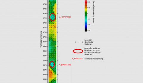
Map of the measured local gravity field of a microgravimetric survey inside a tunnel tube -
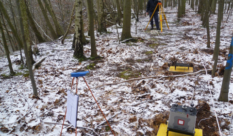
Execution of a micro gravimetric survey for the detection of caviites in the subsurface -
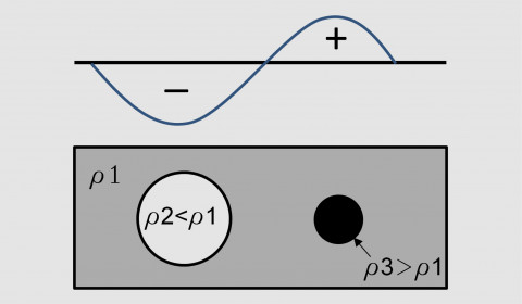
Principle of the resulting gravity over bodies of different density in the underground